
Road networks generate an enormous amount of information every time a vehicle travels across them. Changes in vibration, ride quality, road surface condition, location, and visible pavement distress can all provide clues about how infrastructure is performing.
The challenge is turning those signals into useful, scalable road intelligence.
Fleet Sensor Road Intelligence is an emerging approach that uses vehicles already operating across a road network as a distributed source of road-condition information. By combining smartphone sensors, GPS, imagery, artificial intelligence, and geospatial analytics, road agencies and infrastructure owners can monitor much larger portions of their networks more frequently than would be practical with dedicated surveys alone.
For organizations responsible for thousands of kilometres of roads, this creates an important opportunity: instead of viewing road condition as something assessed periodically through isolated surveys, it can become an ongoing stream of infrastructure intelligence.
RoadBounce supports this approach through smartphone-based road condition monitoring, helping road agencies, consultants, contractors, and infrastructure owners collect scalable road-condition data, identify deterioration, understand network-level ride quality, and prioritize locations for further investigation and maintenance.
The objective is not to replace engineering-grade road profiling. Traditional profilers remain valuable for detailed engineering investigations, while smartphone-based monitoring solutions provide cost-effective network-wide screening and continuous monitoring.
What Is Fleet Sensor Road Intelligence?
Fleet Sensor Road Intelligence is the process of using data generated by vehicles travelling across a road network to understand road conditions and support infrastructure decisions.
A vehicle can act as a mobile data-collection platform.
Depending on the application, relevant information may include:
- Accelerometer measurements
- GPS location
- Vehicle movement and vibration
- Smartphone sensor data
- Road imagery
- AI-detected pavement distress
- Ride-quality indicators
- Road segment condition information
- Historical condition observations
Individually, these signals may have limited value. When they are processed, georeferenced, analyzed, and viewed over time, they can become a powerful source of road network intelligence.
The fundamental concept is straightforward:
Vehicle movement → Sensor data → Analysis → Road condition information → Infrastructure decisions
This allows road owners to move from occasional observations toward more continuous awareness of how their networks are performing.
Why Fleet-Based Road Intelligence Matters
Road agencies rarely have unlimited budgets, survey resources, or maintenance capacity.
At the same time, road networks are constantly changing.
Weather, traffic loading, heavy vehicles, drainage problems, utility work, pavement age, construction quality, and repeated environmental exposure can all contribute to deterioration.
A road may therefore change considerably between formal engineering surveys.
This creates a fundamental infrastructure-management challenge:
How can an organization maintain visibility across an entire road network between detailed surveys?
Fleet-based monitoring provides one answer.
Instead of collecting road-condition information only when a dedicated survey vehicle is deployed, smartphones and vehicle sensors can potentially collect observations while vehicles are already travelling their normal routes.
This can support:
- Network-wide screening
- More frequent road assessments
- Early identification of deterioration
- Maintenance prioritization
- Condition trend analysis
- GIS-based road intelligence
- Identification of locations requiring detailed investigation
For a road authority managing a large network, the value is not simply collecting more data. The value is knowing where attention is required and when.
How Fleet Vehicles Become Mobile Road Sensors
A traditional road survey typically involves deploying specialized equipment to systematically measure specific pavement characteristics.
Fleet Sensor Road Intelligence takes a different approach.
The vehicle is already travelling the road. Sensors attached to or contained within the vehicle can capture information about the vehicle’s response to the pavement.
A simplified architecture looks like this:
Fleet vehicle
↓
Smartphone sensors / vehicle data / imagery
↓
GPS positioning
↓
Data processing
↓
AI and analytical models
↓
Road-condition indicators
↓
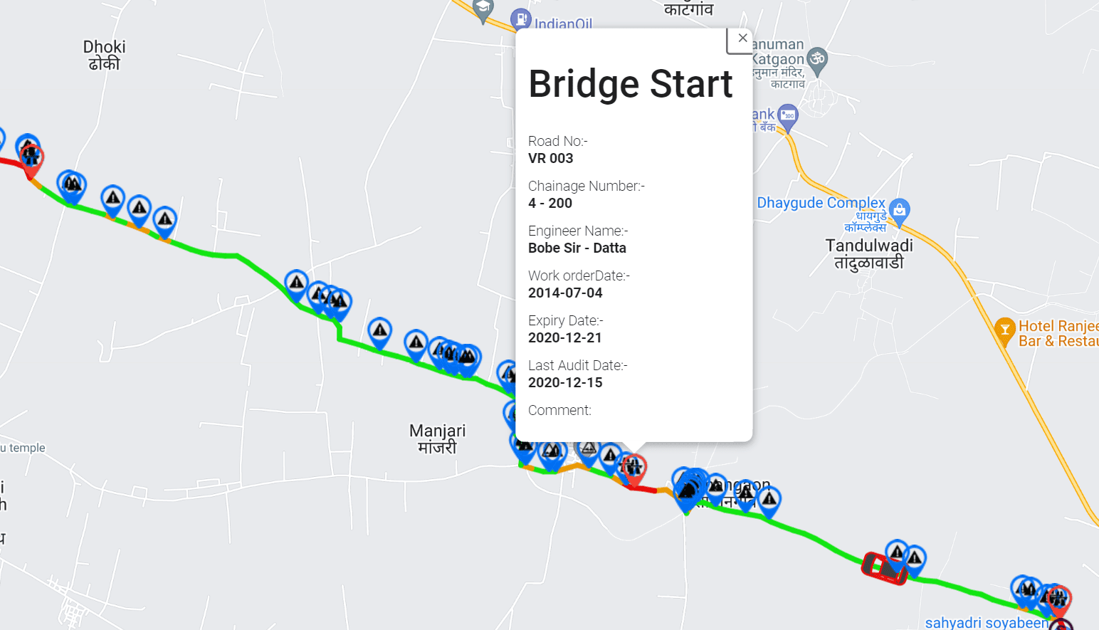
GIS road network
↓
Maintenance and engineering decisions
The important advantage is scalability.
A road authority does not necessarily need to send a dedicated survey vehicle across every kilometre every time it wants to understand whether conditions are changing.
Instead, existing journeys can contribute to an ongoing picture of network condition.
What Data Can Fleet Sensors Collect?
The exact data available depends on the vehicle, smartphone, sensors, application, and survey methodology.
However, several data types are particularly useful for road intelligence.
Accelerometer Data
Accelerometers measure changes in acceleration along different axes.
When a vehicle travels across uneven pavement, potholes, bumps, patches, joints, depressions, or other surface irregularities, those movements can create measurable changes in the sensor signal.
Processed appropriately, these signals can help characterize ride quality and identify potentially problematic road segments.
RoadBounce uses smartphone-based sensing to support road-condition monitoring and ride-quality assessment at network scale.
GPS Data
Sensor measurements become substantially more useful when they are associated with accurate geographic locations.
GPS allows road-condition observations to be mapped to:
- Road segments
- Lanes or carriageways where applicable
- Routes
- Administrative areas
- Maintenance zones
- Asset-management databases
This transforms individual sensor observations into a spatial infrastructure dataset.
A road agency can move from asking:
“Was a rough event detected?”
to:
“Where is the roughness occurring, and which road segment does it affect?”
Camera and Visual Data
Road condition is not defined by roughness alone.
Some pavement defects are better understood visually.
Depending on the system and survey configuration, imagery can support identification of visible pavement distress and other road anomalies.
AI-based visual inspection can help organize large volumes of road imagery and highlight locations that warrant human review or further investigation.
This creates an important complement to sensor-based ride-quality measurements.
From Fleet Data to Road Intelligence
Collecting sensor data is only the beginning.
The real value comes from transforming raw measurements into information that infrastructure teams can use.
A typical road-intelligence workflow can be represented as:
1. Data Collection
Vehicles travel their normal routes while sensors collect relevant information.
2. Positioning
Each observation is associated with a geographic location.
3. Data Processing
Raw signals are cleaned and processed to reduce noise and improve consistency.
4. Feature Extraction
Relevant characteristics of the sensor and image data are identified.
5. AI and Analytics
Algorithms can help identify patterns associated with road roughness, pavement distress, potholes, bumps, and other anomalies.
6. Road Segmentation
Observations can be associated with defined road sections for network-level analysis.
7. Visualization
Results can be displayed through maps, dashboards, reports, or GIS environments.
8. Decision Support
Road owners can use the resulting information to prioritize inspections, maintenance, rehabilitation planning, and detailed engineering investigations.
The transition from raw data to decision-ready intelligence is what makes Fleet Sensor Road Intelligence valuable.
How RoadBounce Fits Into Fleet Sensor Road Intelligence
RoadBounce is designed around the principle that road-condition information should be scalable enough to support monitoring across large networks.
Its smartphone-based approach can help road agencies, consultants, contractors, and infrastructure owners collect road-condition information without requiring a dedicated specialized survey vehicle for every monitoring exercise.
RoadBounce can bring together several complementary information sources, including:
- Smartphone-based road condition measurements
- Ride-quality and roughness assessment
- AI-assisted visual inspection
- GPS-based mapping
- GIS-integrated road intelligence
- Recurring road monitoring
This allows organizations to create a broader view of network condition.
The resulting information can help answer practical questions such as:
- Which parts of the network are showing signs of deterioration?
- Which road segments should receive closer attention?
- Where are recurring road anomalies occurring?
- Which locations may require detailed engineering investigation?
- Where should limited maintenance resources be prioritized?
- How is road condition changing between assessment cycles?
This is where RoadBounce’s role is particularly relevant: not as a replacement for specialized engineering profiling, but as a scalable layer of network intelligence between detailed surveys.
Network Screening vs Engineering Validation
One of the most important distinctions in modern road-condition monitoring is the difference between network screening and engineering validation.
These two functions serve different purposes.
| Network Screening | Engineering Validation |
|---|---|
| Covers large portions of the road network | Focuses on selected locations |
| Designed for scalable monitoring | Designed for detailed investigation |
| Supports frequent or recurring assessments | Typically used for specific engineering requirements |
| Identifies priority locations | Characterizes pavement condition in greater detail |
| Uses practical, scalable data-collection methods | Uses specialized engineering survey equipment |
| Supports maintenance prioritization | Supports engineering decisions and validation |
RoadBounce belongs primarily on the network-screening and continuous-monitoring side of this framework.
Traditional road profilers remain highly valuable when detailed engineering measurements and validation are required.
A practical road-management strategy can therefore use both.
Network-wide screening
Use smartphone-based monitoring to identify condition trends and priority locations across the broader network.
↓
Priority identification
Use road intelligence to determine where additional attention is warranted.
↓
Engineering investigation
Deploy specialized equipment and engineering expertise to priority locations.
↓
Maintenance or rehabilitation decision
Use the combined evidence to determine the appropriate intervention.
This complementary model can help organizations deploy expensive specialist surveys more strategically.
Why Continuous Road Monitoring Matters
A single road-condition survey provides a snapshot.
Continuous or recurring monitoring can provide a trend.
That distinction is critical for pavement management.
Consider a road segment that receives a moderate condition score during one survey.
Without additional observations, an asset manager may not know whether the segment is:
- Stable
- Improving
- Deteriorating slowly
- Deteriorating rapidly
Recurring monitoring can provide additional context.
For example:
Assessment 1 → Baseline condition
Assessment 2 → Early deterioration
Assessment 3 → Significant deterioration
Assessment 4 → Maintenance required
This creates the possibility of moving from reactive maintenance toward more informed preventive maintenance planning.
The earlier deterioration is recognized, the more opportunity infrastructure managers may have to evaluate appropriate interventions before problems become significantly more expensive.
Using Fleet Sensor Intelligence for Maintenance Prioritization
Road agencies frequently face a difficult allocation problem.
There may be hundreds or thousands of road segments requiring attention, but only a limited annual maintenance budget.
The question is therefore not simply:
“Which roads are poor?”
It is:
“Which roads should we address first?”
Fleet Sensor Road Intelligence can contribute to this prioritization process by providing network-scale evidence.
Condition information can potentially be combined with:
- Road classification
- Traffic volumes
- Road criticality
- Historical condition
- Distress observations
- Maintenance history
- Asset importance
- Geographic factors
- Safety considerations
- Engineering assessments
This creates a more informed prioritization framework.
RoadBounce can serve as one layer within that broader pavement and infrastructure management process.
Combining IRI, AI Inspection and GIS
One of the strengths of a modern road-intelligence platform is the ability to combine different forms of information.
IRI and Ride Quality
International Roughness Index, or IRI, is widely used to characterize longitudinal road roughness.
Smartphone-based monitoring can provide scalable ride-quality information that helps road agencies understand how different sections of a network are performing.
However, the purpose of network-scale monitoring is different from detailed engineering validation.
RoadBounce can help identify network-level patterns and priority areas, while specialized profilers can be deployed when detailed engineering measurements are required.
AI Visual Inspection
Visual inspection provides another dimension.
A road may exhibit visible distress that is not fully represented by a single roughness indicator.
AI-assisted inspection can help identify and organize visible road defects at scale.
Combined with sensor-derived information, this creates a richer picture of pavement condition.
GIS Mapping
Location turns individual observations into infrastructure intelligence.
GIS integration allows organizations to visualize road condition geographically and connect observations with existing asset-management systems.
A map can reveal patterns that are difficult to identify from spreadsheets alone.
For example:
- Multiple defects concentrated along one corridor
- Deterioration around a specific road section
- Repeated roughness observations
- Clusters of pavement distress
- Geographic maintenance priorities
The result is a road network that can be analyzed as a connected infrastructure system rather than as a collection of isolated survey points.
The Role of AI in Fleet Road Intelligence
Artificial intelligence can help convert large volumes of raw road data into usable information.
For example, AI and machine-learning techniques can be applied to tasks such as:
- Image classification
- Pavement distress detection
- Road anomaly identification
- Pattern recognition
- Data categorization
- Condition trend analysis
- Automated prioritization support
The advantage becomes more significant as the monitored network grows.
A human team manually reviewing every image and every sensor observation from a large fleet would quickly encounter a scalability challenge.
AI can help organize the data so that human experts can focus their attention where it matters most.
Importantly, AI should support engineering and infrastructure teams rather than eliminate engineering judgment.
Fleet Sensor Road Intelligence for Road Agencies
Road authorities can use network-scale monitoring to improve visibility across their infrastructure portfolios.
Potential applications include:
Network Condition Screening
Rapidly assess large portions of the network and identify areas requiring attention.
Maintenance Planning
Use condition information to support maintenance prioritization.
Recurring Monitoring
Repeat assessments to identify changes in road condition over time.
Engineering Survey Planning
Use network screening to identify locations where detailed surveys should be considered.
Infrastructure Intelligence
Combine road observations with GIS and existing asset-management information.
This can help road agencies make better use of both their data and their engineering resources.
Fleet Sensor Road Intelligence for Commercial Fleets
The concept also has value beyond government road authorities.
Logistics operators, delivery companies, public transportation organizations, and other commercial fleets operate across extensive road networks every day.
Their vehicles experience road conditions continuously.
Road intelligence can therefore help fleet operators understand:
- Which routes are particularly rough
- Where road anomalies occur
- Which routes may contribute to poor ride quality
- Where recurring road problems exist
- Which road conditions may affect route planning
- Where infrastructure issues should be reported or escalated
This creates a bridge between fleet intelligence and infrastructure intelligence.
The same journey that transports goods or passengers can also generate useful information about the road environment.
From Telematics to Road Intelligence
Fleet telematics traditionally focuses on the vehicle.
Typical telematics questions include:
- Where is the vehicle?
- How fast is it travelling?
- How much fuel is it consuming?
- Is the driver braking aggressively?
- How is the vehicle being operated?
Fleet Sensor Road Intelligence introduces another question:
What is the road doing to the vehicle?
This shifts the perspective from vehicle-only intelligence to the relationship between vehicle, road, and environment.
That information can be valuable for both fleet operators and road owners.
For road authorities, it provides another source of infrastructure condition information.
For fleets, it can provide greater visibility into route quality.
For infrastructure managers, it can become another input into broader asset-management decisions.
Creating a Digital Road Condition Map
Imagine a road network where every monitored journey contributes observations to a digital map.
Over time, that map can become richer.
A road segment might contain information about:
- Historical roughness
- Recent sensor observations
- Detected anomalies
- Visual pavement distress
- Inspection history
- Maintenance activity
- Condition trends
This creates the foundation for a digital road condition intelligence layer.
Instead of asking an asset manager to interpret thousands of individual observations, the platform can help present the information at the road-segment and network level.
The result is a more connected approach to infrastructure management.
How Fleet Sensor Intelligence Supports Preventive Maintenance
Traditional maintenance programs can become heavily reactive when condition information is incomplete or infrequent.
A road is repaired after complaints increase, defects become visible, or deterioration reaches an obvious threshold.
More frequent monitoring creates an opportunity to identify changes earlier.
A potential workflow is:
Monitor
↓
Detect
↓
Prioritize
↓
Investigate
↓
Intervene
↓
Monitor again
This creates a continuous feedback loop.
RoadBounce can contribute to the monitoring and screening stages of this cycle, helping infrastructure teams maintain visibility across the network and identify locations that may warrant further attention.
RoadBounce and the Future of Network-Wide Road Monitoring
The future of road management is unlikely to depend on one technology alone.
Specialized profilers, visual inspections, pavement testing, asset-management systems, GIS, connected vehicles, smartphones, and AI can all have different roles.
The opportunity is to connect these technologies intelligently.
A scalable road-monitoring strategy could look like this:
Layer 1 — Continuous Network Monitoring
Smartphones and vehicle-based sensing provide recurring network-level observations.
Layer 2 — AI and Analytics
Large volumes of information are processed and converted into actionable indicators.
Layer 3 — Network Screening
Road agencies identify deteriorating or high-priority segments.
Layer 4 — Engineering Validation
Specialized survey vehicles and engineering teams investigate selected locations in greater detail.
Layer 5 — Maintenance Management
The combined evidence informs intervention planning and investment decisions.
Layer 6 — Recurring Monitoring
The network is monitored again to evaluate changes over time.
This is not a choice between smartphone monitoring and engineering-grade profiling.
It is a tiered road-intelligence strategy in which each technology is used where it provides the greatest value.
Why Fleet Sensor Road Intelligence Is Becoming Important
Road networks are too large, dynamic, and important to be understood through occasional snapshots alone.
Infrastructure owners need better visibility.
They need to know:
- What is changing?
- Where is it changing?
- How quickly is it changing?
- Which locations deserve attention?
- Where should engineering resources be deployed?
- How should maintenance budgets be prioritized?
Fleet Sensor Road Intelligence provides a scalable way to help answer those questions.
By using vehicles already travelling across the network, organizations can create a continuous source of road-condition information.
And with platforms such as RoadBounce, smartphone-based monitoring can become part of a broader infrastructure-intelligence strategy that combines network-wide screening, recurring monitoring, AI-powered inspection, ride-quality assessment, GIS mapping, and engineering validation.
The objective is not to replace specialized engineering surveys.
It is to make the road network more visible between them.
Frequently Asked Questions
What is Fleet Sensor Road Intelligence?
Fleet Sensor Road Intelligence is the use of vehicle-generated sensor, GPS, imagery, and related data to monitor road conditions and create actionable information about road networks.
How does smartphone-based road monitoring work?
Smartphone sensors such as accelerometers can capture vehicle movement and vibration while GPS associates observations with geographic locations. Data can then be processed to generate road-condition and ride-quality insights.
Can fleet vehicles be used for road-condition monitoring?
Yes. Vehicles already travelling normal routes can serve as mobile data-collection platforms, allowing organizations to gather road-condition information without relying exclusively on dedicated survey journeys.
Does RoadBounce replace traditional road profilers?
No. RoadBounce is designed for network-scale screening, recurring monitoring, and infrastructure intelligence. Traditional profilers remain valuable for detailed engineering investigations and validation.
What is the difference between network screening and engineering validation?
Network screening focuses on covering larger areas efficiently and identifying locations that require attention. Engineering validation uses specialized equipment and engineering methods to investigate selected locations in greater detail.
Can Fleet Sensor Road Intelligence help with maintenance prioritization?
Yes. Network-scale condition information can help infrastructure teams identify priority road segments and support data-driven maintenance planning.
Can AI detect pavement distress?
AI-based visual inspection can help identify and classify visible pavement distress and road anomalies at scale. Such outputs should be used as decision-support information alongside appropriate engineering review.
Why is recurring road monitoring important?
Road condition changes over time. Recurring monitoring can help identify deterioration trends between detailed engineering surveys and provide more current information for maintenance planning.
Conclusion
Fleet Sensor Road Intelligence represents a shift in how road networks can be monitored.
Instead of treating road surveys as isolated events, infrastructure owners can use smartphones, vehicle sensors, GPS, imagery, AI, and GIS to create a more continuous view of network condition.
The value lies in scale and frequency.
More monitoring → earlier visibility → better prioritization → more targeted engineering investigation → better-informed maintenance decisions.
RoadBounce supports this network-intelligence approach by providing smartphone-based road condition monitoring that can help organizations screen large networks, measure ride quality, identify potential deterioration, integrate road observations with geographic information, and determine where further investigation may be required.
The future is not about choosing between smartphone technology and specialized engineering equipment.
It is about using both intelligently.
Traditional profilers provide detailed engineering validation where required. RoadBounce helps provide the network-wide visibility needed to know where that detailed attention matters most.


Leave a Reply