
Potholes are among the most common and costly challenges facing road agencies, municipal authorities, highway operators, and infrastructure asset managers. Beyond affecting driving comfort, they can compromise road safety, accelerate pavement deterioration, increase vehicle operating costs, and create significant maintenance challenges.
Although potholes can develop throughout the year, weather conditions and seasonal changes play a major role in how quickly pavement deteriorates. Heavy rainfall, temperature fluctuations, freeze-thaw cycles, prolonged heat, and changing moisture conditions can weaken pavement structures and accelerate the formation of surface defects.
For infrastructure managers, understanding these environmental influences is essential for moving from reactive repairs to preventive maintenance planning. However, identifying the influence of weather alone is not enough. Road agencies also need reliable ways to monitor pavement conditions across extensive road networks and identify locations where deterioration requires attention.
This is where network-wide road condition monitoring becomes valuable. RoadBounce combines smartphone-based road surveys, ride quality measurements, AI-powered visual inspections, and GIS-integrated analytics to help infrastructure stakeholders monitor road conditions, identify potential pavement distress, and prioritize maintenance interventions.
By combining environmental awareness with recurring road condition assessments, road agencies can make better-informed decisions about where to inspect, investigate, and maintain their road networks.
1. How Weather Contributes to Pothole Formation
Potholes rarely develop because of a single environmental factor. In many cases, they emerge through a combination of moisture infiltration, pavement weaknesses, traffic loading, material deterioration, and temperature-related stresses.
A typical pothole formation process begins when water enters cracks, joints, or other openings in the pavement. As moisture reaches the underlying layers, it can weaken the supporting materials and reduce their ability to withstand repeated traffic loads. Over time, vehicle tyres generate stresses that loosen pavement material, allowing small defects to expand into larger cavities.
The process may accelerate when changing weather conditions repeatedly expose the pavement to moisture, heat, or freezing temperatures.
Several environmental factors influence this process:
- Rainfall: Allows water to enter pavement cracks and damaged surfaces.
- Temperature fluctuations: Cause pavement materials to expand, contract, or experience thermal stress.
- Freeze-thaw cycles: Can damage moisture-affected pavement in climates where water freezes and thaws repeatedly.
- Prolonged heat: Can soften certain asphalt mixtures and contribute to deformation under heavy traffic.
- Seasonal moisture changes: Influence drainage, subgrade conditions, and pavement strength.
The impact varies according to pavement design, material quality, drainage performance, traffic volume, construction practices, and existing road condition. Understanding these interactions helps infrastructure managers identify when and where deterioration risks may increase.
2. Heavy Rainfall and Water Infiltration
Rainfall is a major contributor to pothole development, particularly when pavements already contain cracks, damaged joints, failed patches, or inadequate drainage systems.
When rainwater accumulates on the road surface, it can penetrate these openings and reach the underlying pavement layers. Repeated traffic loading then places stress on the moisture-affected structure, potentially causing material displacement, loss of support, and progressive surface failure.
How rainfall accelerates pothole formation
Water infiltration: Cracks and surface defects provide pathways for water to enter the pavement structure.
Reduced structural support: Moisture can weaken susceptible unbound layers and subgrade soils, reducing their capacity to support traffic loads.
Traffic-induced damage: Repeated wheel loads can dislodge weakened asphalt and aggregate, gradually enlarging existing defects.
Drainage-related deterioration: Blocked drains, standing water, and poorly designed drainage systems can increase the duration of moisture exposure.
These effects can be particularly important during monsoon seasons, when repeated rainfall events may leave pavement surfaces and underlying layers exposed to prolonged moisture.
For road agencies, the challenge is not simply to identify potholes after heavy rain. It is to understand which road sections are deteriorating, how the condition is changing, and where further investigation or maintenance should be prioritized.
Recurring road condition surveys can help identify emerging surface defects and changing ride quality following rainfall events. GIS-based mapping further helps agencies connect reported defects with specific road segments, supporting more organized inspections and maintenance planning.
3. Temperature Fluctuations and Pavement Stress
Temperature changes affect pavement materials differently depending on their composition, structural design, age, and environmental exposure.
As temperatures rise and fall, pavement materials undergo thermal expansion and contraction. Repeated fluctuations can contribute to stress development, particularly where existing cracks, joints, material weaknesses, or restrained movement are present.
These stresses may widen existing cracks or create conditions that allow water to penetrate the pavement structure. When moisture and traffic loading act on these weakened areas, the risk of progressive deterioration can increase.
The impact of hot weather
High temperatures can soften asphalt binders and increase the susceptibility of some asphalt mixtures to deformation, particularly under heavy or slow-moving traffic. Depending on the pavement design and material properties, this may contribute to rutting, shoving, or other surface defects.
Although heat alone does not necessarily produce potholes, deformation and cracking can create conditions that allow subsequent moisture infiltration and material loss.
The impact of cold weather
In colder climates, low temperatures can make asphalt mixtures more susceptible to thermal cracking when contraction stresses exceed the pavement’s capacity to accommodate them.
Water can enter these cracks and contribute to further damage. In areas that experience freezing conditions, the interaction between moisture, freezing temperatures, and repeated traffic loading can accelerate deterioration.
For infrastructure managers, seasonal temperature changes provide useful context for interpreting road condition trends. Combining this context with recurring road surveys can help identify sections that require closer attention before defects become more extensive.
4. Freeze-Thaw Cycles: A Significant Cause of Potholes in Cold Climates
Freeze-thaw cycles are an important mechanism of pavement deterioration in regions where temperatures repeatedly move above and below the freezing point.
When water enters cracks or moisture-sensitive pavement layers, freezing can cause water to expand. This may exert pressure on surrounding materials and contribute to the widening of existing defects. When the ice melts, water can penetrate further into the damaged structure.
Repeated cycles can progressively weaken the pavement, particularly when the road is already cracked or poorly drained.
Traffic loading adds another dimension to the problem. Vehicles travelling over weakened pavement can displace loose material and enlarge damaged areas, eventually creating potholes.
The typical sequence involves:
- Water entering pavement cracks or damaged areas.
- Temperatures falling below freezing and moisture freezing within the pavement.
- Thawing creating additional opportunities for moisture movement.
- Repeated cycles weakening susceptible pavement materials.
- Traffic loading dislodging weakened material and enlarging the defect.
Not every freeze-thaw cycle produces a pothole, and the severity of damage depends on pavement composition, moisture availability, drainage, traffic, and the number and intensity of temperature fluctuations.
For road agencies operating in cold-weather environments, monitoring pavement conditions before and after winter can help identify locations where deterioration has accelerated. Network screening can then support decisions about which sections warrant detailed engineering assessment and targeted repairs.
5. Monsoon Seasons and Pothole Formation in India
In India, seasonal rainfall presents a substantial road maintenance challenge, particularly in regions exposed to intense monsoon precipitation, waterlogging, and inconsistent drainage performance.
Road networks may include a mixture of highways, arterial roads, local streets, rural roads, and industrial access routes. These roads can differ considerably in pavement design, age, construction quality, traffic loading, and maintenance history.
Consequently, the effects of monsoon weather are not uniform across a road network.
Why monsoon conditions increase pavement deterioration risks
Prolonged rainfall: Repeated rain can increase the time that pavement cracks and damaged surfaces remain exposed to moisture.
Waterlogging: Poor drainage can allow water to accumulate on road surfaces and around pavement edges.
Weak pavement foundations: Moisture-sensitive subgrade soils and underlying layers may lose strength when exposed to excessive water.
Heavy traffic: Trucks, buses, and other vehicles continue loading weakened pavement during and after rainfall.
Delayed maintenance: Rain, flooding, and restricted access can complicate inspections and repair schedules.
These factors can combine to create widespread deterioration across multiple road sections. A pothole that appears small initially may become significantly larger if water infiltration and traffic loading continue.
The importance of post-monsoon road assessments
A post-monsoon assessment can help road agencies understand how pavement conditions have changed during the rainy season.
Rather than relying exclusively on isolated complaints or manual inspections, infrastructure managers can use systematic road surveys to identify sections showing deteriorating ride quality or visible surface distress.
Smartphone-based monitoring can support these assessments by collecting road condition data across large networks. AI-powered visual inspection capabilities can help identify potential pavement defects, while GIS-integrated analytics can organize observations by road segment and location.
These insights can help maintenance teams prioritize field inspections, plan repairs, and determine where more detailed engineering investigations are necessary.
The objective is not to assume that every road will deteriorate after the monsoon. It is to establish a repeatable process for measuring changes in road condition and responding to emerging risks.
6. Seasonal Changes and Their Impact on Different Types of Roads
Weather-related pavement deterioration depends partly on the road’s construction, materials, usage, and surrounding environment.
| Road type | Seasonal risk factors | Monitoring priority |
|---|---|---|
| Urban roads | Waterlogging, utility cuts, frequent braking, and heavy traffic | Identify recurring surface defects and deteriorating road sections |
| National and state highways | Heavy axle loads, rainfall, drainage issues, and temperature variation | Screen extensive corridors and identify locations requiring detailed investigation |
| Rural roads | Moisture-sensitive soils, limited drainage, and seasonal accessibility challenges | Track condition changes and prioritize maintenance across dispersed networks |
| Industrial access roads | Heavy commercial vehicles, concentrated loading, and surface deformation | Monitor changes in ride quality and potential pavement distress |
| Roads in cold climates | Freeze-thaw cycles, thermal cracking, and winter moisture exposure | Compare pavement conditions before and after winter |
This comparison illustrates why a single inspection strategy may not be sufficient for every road network. Maintenance planning should consider local climate, pavement characteristics, traffic patterns, and historical deterioration.
A scalable monitoring approach can help agencies identify where environmental exposure and observed road conditions justify closer investigation.
7. Early Warning Signs That Weather-Related Potholes May Develop
Recognizing early signs of pavement deterioration allows infrastructure managers to investigate potential problems before they become more extensive.
Some defects do not inevitably develop into potholes, but they can indicate weaknesses that deserve attention, particularly when combined with persistent moisture exposure or heavy traffic.
Common warning signs include:
Alligator cracking
Interconnected cracks resembling a reptile’s scales can indicate fatigue-related distress and potentially inadequate structural support. These areas may become vulnerable to moisture infiltration and further material loss.
Longitudinal and transverse cracks
Cracks running along or across the pavement can provide pathways for water to enter. Their significance depends on their width, depth, location, and underlying cause.
Surface raveling
Raveling occurs when aggregate particles become detached from the pavement surface. It may indicate deterioration of the asphalt mixture or binder and can leave the surface increasingly vulnerable to further damage.
Depressions and standing water
Low areas that retain water can indicate surface deformation or drainage problems. Persistent moisture may increase deterioration risks when the pavement structure is vulnerable.
Failed patches
Repairs that crack, loosen, or deteriorate again may indicate unresolved underlying issues, material incompatibility, drainage problems, or repeated traffic stresses.
Declining ride quality
Changes in ride quality may indicate developing pavement irregularities or broader deterioration. Ride quality measurements can help screen road sections for further investigation, although they do not independently identify every type of pavement distress.
Tracking these indicators over time provides a stronger basis for maintenance planning than relying solely on individual observations.
8. Why Traditional Road Inspections May Not Be Enough for Large Networks
Traditional road inspections remain essential for assessing pavement defects, verifying conditions, and determining appropriate maintenance treatments. However, monitoring extensive networks through manual inspections alone can present operational challenges.
Large road networks may contain thousands of kilometres of pavement, making it difficult to inspect every road frequently using labour-intensive methods. Inspection intervals may become longer, and road conditions can change considerably between assessments.
Weather-related deterioration makes this challenge more significant because defects can develop or expand between scheduled inspections.
Common challenges include:
- Limited inspection coverage across extensive networks.
- High operational demands associated with repeated field surveys.
- Inconsistent intervals between condition assessments.
- Difficulty comparing road conditions across different periods.
- Delays in identifying deteriorating road sections.
- Challenges prioritizing maintenance when resources are limited.
These constraints highlight the value of supplementing traditional inspection practices with scalable road condition monitoring.
Smartphone-based road surveys can help collect condition data across wider areas, while recurring assessments make it easier to compare observations over time. The resulting information supports network-level screening and helps identify where specialized inspection resources should be deployed.
Traditional profilers and detailed engineering surveys remain important for accurate characterization and validation when required. Network screening helps direct these specialized resources towards locations where they can provide the greatest decision-making value.
9. How RoadBounce Supports Weather-Responsive Road Monitoring
Road agencies need more than a list of potholes to manage weather-related deterioration effectively. They need a practical way to understand road conditions across their networks, identify changes over time, and direct maintenance resources towards priority locations.
RoadBounce is a smartphone-based road condition monitoring and infrastructure intelligence platform designed to support this process.
By combining network-scale data collection with road condition analytics, RoadBounce helps infrastructure stakeholders move beyond isolated observations towards more systematic pavement monitoring.
Network-wide road condition screening
RoadBounce supports the collection of road condition data across extensive networks, helping agencies understand where road conditions may be deteriorating.
This is particularly valuable when seasonal changes create the need for broader assessments, such as following heavy rainfall or after winter weather.
Smartphone-based ride quality measurements
Smartphone-based surveys can support ride quality monitoring and help identify road sections that may warrant further investigation.
These measurements provide a scalable screening approach, complementing specialized profiling methods used for detailed engineering assessments.
AI-powered visual pavement inspections
AI-powered visual inspection capabilities can help identify potential pavement distress, including visible surface defects such as cracking and potholes, depending on the data collected and the system’s supported detection capabilities.
When interpreted alongside other road condition indicators, these observations can help maintenance teams investigate emerging issues and organize repair priorities.
GIS-integrated road condition intelligence
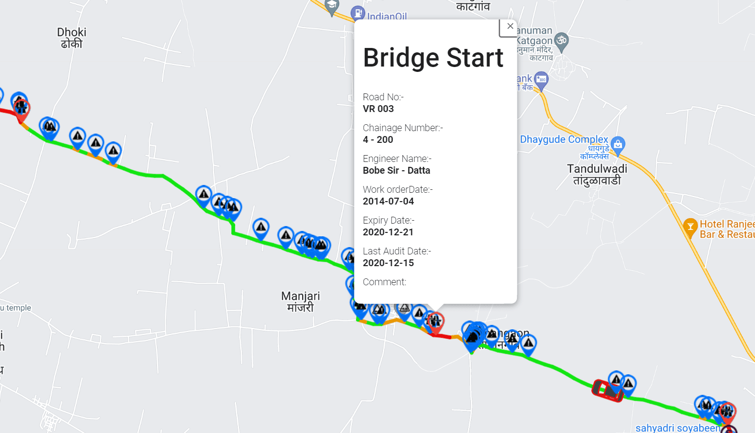
GIS mapping connects road condition observations with geographic locations, helping infrastructure managers understand where defects are occurring and how they are distributed across a network.
This spatial perspective can support maintenance planning, corridor-level assessments, and the identification of road sections that may require additional inspection.
Recurring road condition assessments
Repeated surveys allow agencies to compare road condition observations across different periods.
For example, a road network can be assessed before the monsoon and surveyed again after the rainy season. Comparing the results may help identify sections where ride quality or visible pavement conditions have deteriorated.
Seasonal comparisons can also support post-winter assessments in colder climates and recurring monitoring throughout the year.
Maintenance prioritization
RoadBounce can help agencies organize road condition information to support more informed maintenance decisions.
By combining ride quality measurements, visual inspection findings, and GIS-based information, infrastructure teams can identify candidate locations for field inspection, prioritize further investigation, and plan maintenance activities according to their operational requirements.
The final maintenance decision should also consider road classification, traffic exposure, safety implications, pavement structure, repair costs, and engineering assessment findings.
The key advantage is network intelligence: RoadBounce helps road agencies identify where attention may be needed across large networks, rather than depending entirely on isolated inspections or waiting for defects to become severe.
10. Network Screening vs. Engineering Validation: Understanding the Difference
An effective pavement management strategy uses different assessment technologies for different purposes.
Network screening helps infrastructure managers understand road conditions across an entire network and identify locations that deserve attention. Engineering validation provides more detailed measurements and investigations to characterize pavement conditions and support technical decisions.
These approaches are complementary, not competing alternatives.
| Assessment requirement | Network screening with RoadBounce | Traditional road profiling and engineering surveys |
|---|---|---|
| Primary objective | Monitor broad road networks and identify priority locations | Obtain detailed measurements for specific engineering requirements |
| Typical coverage | Extensive road networks and recurring assessments | Selected corridors, projects, or investigation locations |
| Ride quality monitoring | Smartphone-based measurements for screening and monitoring | Specialized profiling equipment for detailed measurement requirements |
| Visible distress identification | AI-assisted visual inspection, subject to system capabilities | Detailed field inspection and appropriate diagnostic methods |
| Maintenance planning | Supports network-level prioritization | Supports treatment design, technical evaluation, and validation |
| Role in a wider program | Identify where further attention may be needed | Investigate and validate conditions at selected locations |
Traditional profilers remain valuable for detailed engineering investigations, while smartphone-based monitoring solutions provide cost-effective network-wide screening and continuous monitoring.
For example, a road agency might conduct a network-wide assessment after the monsoon and identify several corridors showing deteriorating ride quality and visible distress. The agency could then deploy specialized survey vehicles and engineering teams to selected locations for more detailed measurements and diagnosis.
This workflow helps align specialized investigations with identified priorities while maintaining the technical rigour required for engineering decisions.
RoadBounce is intended to support network screening, monitoring, and maintenance prioritization. It is not a replacement for engineering-grade profiling, acceptance testing, or engineering validation surveys.
11. Building a Seasonal Road Monitoring and Maintenance Strategy
A structured monitoring programme can help road agencies understand how seasonal conditions affect pavement performance and plan maintenance more effectively.
The precise schedule should reflect local weather patterns, road classification, traffic volumes, pavement condition, available resources, and operational requirements.
A practical framework includes the following stages.
Stage 1: Establish baseline road conditions
Conduct an initial network assessment to understand existing ride quality, visible pavement distress, and the distribution of potentially problematic road sections.
This baseline provides a reference point for future comparisons.
Stage 2: Identify seasonal exposure and risk factors
Review rainfall patterns, drainage performance, historical defect reports, traffic loading, pavement age, and previous maintenance records.
Use this information to identify road sections that may warrant more frequent monitoring.
Stage 3: Increase monitoring around relevant weather events
Where operationally appropriate, conduct additional assessments before and after high-risk seasonal periods, including monsoon rainfall, prolonged wet weather, or winter freeze-thaw conditions.
These assessments can help reveal changes in road condition that might otherwise remain undocumented between routine inspections.
Stage 4: Map and screen potential problem areas
Use ride quality observations, visual inspection findings, and geographic information to identify candidate locations for further investigation.
Prioritize locations according to the severity of observed deterioration, safety concerns, traffic importance, and available evidence.
Stage 5: Validate priority locations
Deploy field inspection teams and specialized profiling equipment where detailed measurements, structural diagnosis, or engineering validation are required.
This step ensures that network screening findings are followed by appropriate technical assessment.
Stage 6: Plan preventive and corrective maintenance
Use the combined findings to determine appropriate interventions, ranging from localized repairs and drainage improvements to more substantial pavement rehabilitation.
The correct treatment depends on the underlying cause of deterioration, not simply the visible presence of a pothole.
Stage 7: Repeat assessments and evaluate outcomes
Conduct recurring surveys to monitor road condition changes and review whether completed maintenance has improved the condition of the selected road sections.
Over time, these observations can support better maintenance scheduling, more informed resource allocation, and a clearer understanding of seasonal deterioration patterns.
12. Benefits of Proactive, Data-Driven Pothole Management
A proactive approach to pavement monitoring can improve how infrastructure owners identify problems, allocate budgets, and evaluate maintenance needs.
Earlier identification of emerging deterioration
Recurring road assessments can help identify changes in pavement condition before maintenance teams rely solely on public complaints or visible severe damage.
Better maintenance prioritization
Network-wide data helps agencies compare road sections and direct inspections towards locations showing concerning conditions or changes.
More efficient deployment of specialized resources
Screening can help identify where detailed profiling, field investigation, or engineering validation may be most useful.
Improved seasonal planning
Pre-season and post-season assessments provide a repeatable way to evaluate how road conditions change during periods of increased environmental stress.
More consistent road condition records
Recurring surveys help create a historical record of road condition observations, supporting comparisons between road sections and assessment periods.
Stronger infrastructure asset management
Integrating road condition data with GIS information and maintenance records can help infrastructure teams develop a more comprehensive understanding of network performance.
These benefits depend on appropriate survey design, data quality, consistent collection methods, and the effective use of findings in maintenance decisions. Monitoring does not eliminate pavement deterioration, but it can improve the information available to manage it.
Conclusion: Monitor Road Conditions Before Seasonal Damage Escalates
Weather and seasonal changes influence pothole formation through a combination of moisture infiltration, temperature-related stresses, drainage problems, material deterioration, and repeated traffic loading. The relative importance of each factor depends on the climate, pavement structure, road condition, and traffic environment.
For road agencies, the challenge is to identify changing pavement conditions across extensive networks and determine where inspections and maintenance should be prioritized.
A combination of recurring road surveys, visual pavement inspections, GIS-integrated analytics, and targeted engineering investigations provides a practical foundation for addressing this challenge.
RoadBounce supports this approach by helping infrastructure stakeholders collect road condition data at scale, monitor ride quality, identify potential pavement distress, and prioritize locations for further investigation.
Rather than replacing traditional road profiling, RoadBounce complements detailed engineering assessments by helping agencies identify where specialized resources may be needed.
Smarter road management begins with better network visibility. By combining seasonal awareness with recurring road condition monitoring, infrastructure owners can make more informed maintenance decisions and work towards safer, more resilient, and better-maintained road networks.
Frequently Asked Questions
1. How does rain cause potholes?
Rainwater can enter pavement cracks and damaged areas, weakening susceptible pavement layers. Repeated traffic loading can then dislodge weakened material, causing defects to expand into potholes. Poor drainage and prolonged moisture exposure can increase the risk.
2. Which season causes the most potholes?
There is no universal answer. In regions with heavy monsoon rainfall, wet-season moisture and drainage problems can accelerate pavement deterioration. In colder climates, freeze-thaw cycles are a major concern. Temperature-related pavement stresses and heavy traffic can also contribute throughout the year.
3. Why do potholes often become worse after heavy rainfall?
Heavy rainfall can increase water infiltration into existing pavement defects and expose weaknesses in the pavement structure. Vehicles travelling over these weakened areas can loosen and displace material, enlarging potholes.
4. Can hot weather cause potholes?
Hot weather can contribute to pavement deformation by softening certain asphalt mixtures, particularly under heavy traffic. The resulting defects may become more vulnerable to cracking and moisture infiltration, which can contribute to subsequent pothole formation.
5. How can road agencies identify potholes across large road networks?
Road agencies can combine recurring road surveys, visual inspections, GIS mapping, and condition monitoring systems to identify potential problem areas. Smartphone-based platforms such as RoadBounce support network-wide screening and help prioritize locations for field inspection and detailed engineering assessment.
6. What is the difference between road condition monitoring and road profiling?
Road condition monitoring focuses on assessing and tracking road conditions across networks over time. Specialized road profiling equipment is used to obtain detailed measurements for specific engineering requirements. Both approaches are complementary and can form part of an integrated pavement management programme.
7. How does RoadBounce help with seasonal road monitoring?
RoadBounce supports smartphone-based road surveys, ride quality monitoring, AI-powered visual inspection, and GIS-integrated road condition analysis. By comparing observations across assessment periods, road agencies can identify potentially deteriorating sections and prioritize further inspection and maintenance.
8. Why is post-monsoon road monitoring important?
Post-monsoon monitoring helps road agencies evaluate changes in road condition following seasonal rainfall. It can highlight road sections with worsening ride quality or visible distress and support decisions about field inspections, repairs, and further engineering investigations.
9. Can smartphone-based road monitoring replace engineering-grade profilers?
No. Smartphone-based road monitoring supports scalable network screening and recurring condition assessments, while engineering-grade profilers remain important for detailed measurement requirements and engineering validation. RoadBounce complements these technologies rather than replacing them.
10. How often should roads be monitored for pothole formation?
Monitoring frequency should reflect road importance, pavement condition, traffic exposure, local weather, drainage performance, and available resources. High-risk networks may benefit from additional assessments before and after critical seasonal periods, alongside routine monitoring and inspections.


Leave a Reply