
Potholes are among the most visible and costly challenges facing road authorities, municipal corporations, highway agencies, and infrastructure maintenance teams. Beyond creating an uncomfortable driving experience, deteriorating road surfaces can damage vehicles, increase accident risks, disrupt traffic movement, and accelerate pavement deterioration.
However, repairing every pothole as soon as it appears is not always financially or operationally possible.
Road maintenance teams frequently operate with limited budgets, restricted manpower, competing infrastructure priorities, and extensive road networks that require continuous attention. Under these conditions, the challenge is not simply identifying potholes. It is determining which potholes need attention first, where maintenance resources should be deployed, and how to prevent minor road defects from becoming expensive infrastructure problems.
An effective pothole repair prioritization strategy requires more than occasional visual inspections or public complaints. It requires a systematic approach that combines road condition data, traffic exposure, safety considerations, deterioration trends, and maintenance costs.
With smartphone-based road monitoring, AI-powered pavement inspections, and GIS-integrated infrastructure analytics, road agencies can develop a clearer understanding of network conditions and make more informed maintenance decisions.
This guide explores practical strategies for prioritizing pothole repairs when maintenance budgets are limited.
1. Understand Why Not All Potholes Have the Same Priority
One of the most common mistakes in road maintenance planning is treating every pothole as an equally urgent repair requirement.
In reality, potholes differ significantly in their severity, location, traffic exposure, and potential consequences.
A small pothole on a low-volume residential road may require monitoring and scheduled maintenance. A deep pothole on a busy intersection, school access road, or major traffic corridor may represent a considerably greater safety concern.
Therefore, repair prioritization should consider the overall risk associated with each defect rather than relying exclusively on its physical size.
Road maintenance teams should evaluate several factors:
- Pothole severity: Depth, width, surface deterioration, and the extent of pavement damage.
- Traffic volume: The number and type of vehicles regularly using the affected road.
- Safety exposure: Potential risks to motorcycles, cyclists, pedestrians, and other road users.
- Road importance: Whether the affected section serves as a major transport corridor, emergency route, or important access road.
- Deterioration rate: Whether the defect is expanding or additional pavement damage is developing.
- Repair requirements: The estimated cost, resources, and time required to address the problem.
Evaluating these factors helps agencies distinguish between routine maintenance requirements and locations that need immediate attention.
2. Develop a Risk-Based Pothole Repair Prioritization System
When maintenance budgets are constrained, a risk-based approach provides a more rational way to distribute available resources.
Instead of repairing defects based on the order in which complaints arrive, road agencies can assign priority levels using consistent assessment criteria.
A practical prioritization framework can include three categories.
High-priority repairs
These locations require urgent assessment and appropriate maintenance intervention.
Typical examples include:
- Deep or rapidly expanding potholes.
- Defects on high-traffic roads and major intersections.
- Potholes creating significant risks for two-wheelers and cyclists.
- Damaged surfaces near pedestrian crossings and public transport stops.
- Road defects affecting emergency service access.
Medium-priority repairs
These locations require planned maintenance within an appropriate timeframe.
Examples include:
- Moderate potholes on frequently used secondary roads.
- Multiple surface defects developing within a short road section.
- Potholes showing signs of progressive deterioration.
- Localized pavement damage that could expand if left untreated.
Low-priority repairs
These locations can generally be included in scheduled maintenance programmes, subject to regular reassessment.
Examples include:
- Small, stable defects on low-volume roads.
- Minor surface deterioration without significant immediate safety concerns.
- Isolated defects that do not substantially affect road usability.
Important: Priority categories should guide maintenance planning, not replace engineering judgment, applicable safety requirements, or emergency response procedures.
3. Use Road Condition Data Instead of Relying Only on Complaints
Public complaints are valuable sources of information for identifying road defects. However, they rarely provide a complete picture of network-wide road conditions.
Some damaged locations receive frequent reports because they are highly visible or regularly used by residents. Other defects may remain unnoticed simply because they occur on less frequently travelled roads.
Relying exclusively on complaint-based maintenance can therefore create an uneven distribution of repair resources.
A data-driven approach helps address this limitation.
Road agencies should establish a systematic road condition monitoring programme that collects information across their entire road network.
Useful information includes:
- Pothole locations and distribution.
- Pavement surface deterioration.
- Road roughness and ride quality.
- Visible cracks and surface defects.
- Changes in road condition over time.
- Geographic location and road segment identification.
This information provides a more objective foundation for comparing road sections and identifying locations that require further investigation.
How RoadBounce supports this process
RoadBounce enables smartphone-based road condition monitoring to support network-wide screening and recurring road assessments.
By combining ride quality measurements, AI-assisted visual inspections, and GIS-based mapping, RoadBounce helps infrastructure teams build a broader understanding of road network conditions.
Rather than depending entirely on isolated inspections, agencies can collect road condition information across multiple routes and use the resulting insights to identify deterioration patterns and potential maintenance priorities.
This makes it easier to determine where maintenance teams should investigate further and where specialized engineering surveys may be necessary.
4. Consider Traffic Volume and Road Network Importance
Pothole severity alone does not determine maintenance priority.
The same defect can have different implications depending on the road’s function and the number of people exposed to it.
For example, a pothole on a busy urban arterial may affect thousands of vehicles every day. A similar defect on a lightly travelled access road may have a different level of network impact.
Maintenance planners should therefore consider road hierarchy and traffic exposure when allocating repair budgets.
Important considerations include:
- Average daily traffic.
- Heavy commercial vehicle movement.
- Public transport routes.
- School and hospital access roads.
- Industrial and logistics corridors.
- Emergency service routes.
- Pedestrian and cycling activity.
Combining road condition information with traffic and road network data helps agencies understand which deteriorating sections could have the greatest impact.
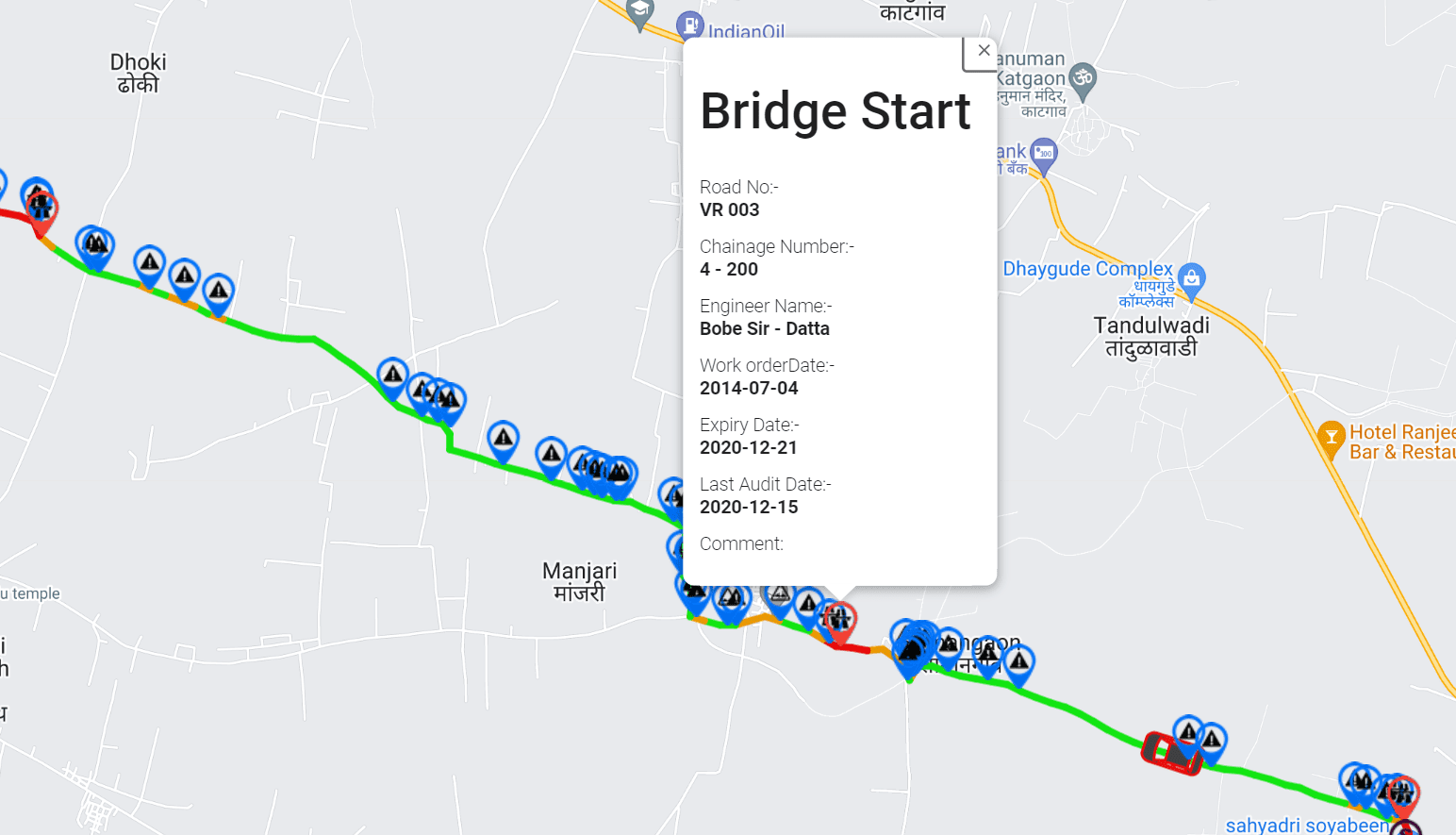
GIS-integrated infrastructure analytics can make this process more efficient by allowing maintenance teams to visualize road defects alongside road classifications, traffic information, and important infrastructure locations.
5. Identify Potholes Early Through Recurring Road Monitoring
Waiting until potholes become severe can significantly increase maintenance complexity.
Pavement deterioration often develops progressively. Small cracks, surface disintegration, water infiltration, and localized material loss can eventually contribute to pothole formation.
If road conditions are assessed only once every few years, agencies may miss important deterioration patterns between surveys.
Recurring road monitoring provides a more proactive alternative.
Instead of relying exclusively on periodic manual inspections, road agencies can conduct more frequent screening assessments using smartphone-based road survey technology.
A recurring monitoring programme can help teams:
- Identify changing road conditions.
- Detect emerging deterioration patterns.
- Compare road condition information between survey periods.
- Identify locations requiring additional inspections.
- Monitor the condition of previously repaired sections.
- Support preventive maintenance planning.
The ability to compare road condition information over time is particularly valuable when budgets are limited.
Agencies can identify which road sections are deteriorating and determine whether preventive intervention may be more appropriate than waiting for extensive pavement damage.
The objective is to identify maintenance needs earlier, not simply to respond faster after potholes become visible.
6. Use AI-Powered Visual Inspections to Improve Defect Identification
Manual road inspections can be time-consuming, especially when maintenance teams are responsible for extensive road networks.
AI-powered visual inspection technologies offer additional support by helping identify visible pavement defects from collected road imagery.
Depending on image quality, available models, and validation procedures, AI-assisted inspection systems can help identify and classify potential road surface issues such as:
- Potholes.
- Longitudinal cracks.
- Transverse cracks.
- Alligator cracking.
- Surface deterioration.
- Other visible pavement defects.
These capabilities can help road agencies organize inspection information, identify potential problem areas, and direct maintenance teams towards locations that need closer examination.
AI should be treated as a decision-support capability rather than an automatic substitute for field verification.
Human inspection and engineering assessment remain important for confirming defect severity, identifying underlying causes, and selecting appropriate repair treatments.
By combining AI-assisted inspections with road condition measurements and GIS mapping, agencies can develop a more comprehensive understanding of infrastructure deterioration.
7. Combine Road Roughness Measurements with Visual Defect Information
A pothole is a visible pavement defect, but it does not necessarily represent the complete condition of a road section.
Road roughness measurements provide another important perspective by helping agencies understand the ride quality experienced by road users.
The International Roughness Index (IRI) is a widely used indicator of longitudinal road profile roughness.
When combined with visual pavement inspection information, IRI measurements can provide a broader understanding of road conditions.
For example:
- Visual inspections can help identify potholes and surface distress.
- IRI measurements can indicate changes in ride quality.
- GIS mapping can connect observations to specific road locations.
- Recurring surveys can help track changes over time.
These different information sources support a more informed maintenance planning process.
RoadBounce brings these capabilities together through smartphone-based road monitoring and infrastructure intelligence.
It is important to distinguish between network-level screening and detailed engineering measurements. Smartphone-based IRI monitoring supports scalable road condition assessment, while specialized road profilers remain valuable for high-resolution engineering investigations and validation where required.
Traditional profilers remain valuable for detailed engineering investigations, while smartphone-based monitoring solutions provide cost-effective network-wide screening and continuous monitoring.
This complementary approach helps agencies identify where detailed engineering investigations should be concentrated rather than deploying specialized survey vehicles across every road section without prior screening.
8. Use GIS Mapping to Identify Repair Clusters and Optimize Maintenance Routes
Repairing individual potholes without considering their geographic distribution can result in unnecessary travel, higher operational costs, and inefficient deployment of maintenance crews.
A more effective approach is to identify clusters of road defects and organize repair activities geographically.
GIS-based road condition mapping helps maintenance teams visualize:
- Pothole locations.
- Concentrations of pavement deterioration.
- High-priority road sections.
- Previously repaired locations.
- Roads requiring further inspection.
- Maintenance activity across different geographical areas.
For example, if several potholes are identified along the same road corridor, the maintenance team may be able to address multiple defects during a single deployment.
This reduces repeated travel and can improve the productivity of available maintenance resources.
Geographic prioritization is especially useful for municipalities and road authorities managing large networks across multiple administrative zones.
With mapped road condition information, maintenance planners can move from isolated repair decisions towards coordinated road maintenance programmes.
9. Balance Immediate Pothole Repairs with Preventive Maintenance
One of the most important decisions for road agencies operating under financial constraints is determining how much of the available budget should be allocated to immediate repairs versus preventive maintenance.
Emergency repairs are necessary when road defects create unacceptable risks or disrupt essential transport routes.
However, directing the entire maintenance budget towards visible damage can leave insufficient resources for preventive interventions.
Preventive maintenance aims to address pavement deterioration before it develops into more extensive structural or surface damage.
Depending on pavement condition and engineering recommendations, suitable treatments may include:
- Crack sealing.
- Surface sealing.
- Localized patching.
- Drainage improvements.
- Surface treatments.
- Planned pavement rehabilitation.
The appropriate treatment depends on pavement structure, defect characteristics, drainage conditions, traffic exposure, and the underlying cause of deterioration.
A well-designed maintenance programme should therefore consider both immediate repair requirements and longer-term pavement preservation needs.
Recurring road monitoring helps agencies identify changing conditions and evaluate where preventive intervention may be appropriate.
This creates opportunities to plan maintenance activities rather than relying entirely on reactive repairs.
10. Establish a Practical Pothole Repair Prioritization Score
Road agencies can improve consistency by developing a weighted scoring framework for evaluating potential repair locations.
The following is an illustrative model that can be adapted to local road conditions, maintenance policies, and safety requirements.
| Assessment factor | Suggested weight |
|---|---|
| Pothole severity | 30% |
| Traffic exposure | 20% |
| Safety risk | 25% |
| Road network importance | 15% |
| Deterioration trend | 10% |
| Total | 100% |
Each factor can be rated on a scale of 1 to 5, where 1 represents a relatively low concern and 5 represents a high concern.
The weighted priority score can be calculated using:
\( P = \sum_{i=1}^{n} W_i \times \frac{R_i}{5} \)
Where:
- P = Overall priority score out of 100.
- Wi = Weight assigned to each assessment factor.
- Ri = Rating assigned to that factor from 1 to 5.
- n = Total number of assessment factors.
Illustrative priority classification:
| Priority score | Suggested classification |
|---|---|
| 80–100 | Very high priority |
| 60–79 | High priority |
| 40–59 | Medium priority |
| Below 40 | Lower priority |
These thresholds are illustrative and should be calibrated to the agency’s maintenance policies and local risk requirements. Critical safety defects should always receive appropriate attention regardless of their calculated score.
A standardized scoring system helps maintenance planners compare locations using consistent criteria, document their decisions, and explain why certain repairs receive priority over others.
11. Track Repair Performance and Measure Maintenance Outcomes
Prioritizing pothole repairs is only one part of effective road asset management.
Agencies should also evaluate whether their maintenance investments are improving road conditions and reducing recurring repair requirements.
Without performance monitoring, it can be difficult to determine whether maintenance budgets are being allocated effectively.
Useful performance indicators include:
- Number of potholes identified.
- Number of high-priority defects repaired.
- Average time between defect identification and repair.
- Percentage of identified defects addressed.
- Recurrence of potholes at previously repaired locations.
- Road condition changes between monitoring periods.
- Maintenance expenditure per road kilometre.
- Percentage of the network assessed during each survey cycle.
These indicators help agencies understand the effectiveness of their maintenance programmes.
For example, recurring potholes at the same locations may indicate underlying drainage problems, pavement structural weaknesses, or unsuitable repair treatments.
Identifying such patterns allows maintenance teams to investigate the root cause rather than repeatedly spending money on temporary repairs.
Road condition monitoring platforms can support this process by providing recurring assessment data that helps agencies track infrastructure changes and evaluate maintenance priorities.
12. Build a Smarter Road Maintenance Strategy with RoadBounce
Managing potholes across extensive road networks requires more than a reactive inspection and repair process.
Road agencies need reliable information about where deterioration is occurring, how road conditions are changing, and which locations deserve further investigation.
RoadBounce supports this requirement through smartphone-based road condition monitoring and infrastructure intelligence.
Its network screening approach combines multiple sources of road condition information to help infrastructure stakeholders make more informed maintenance decisions.
Key capabilities include:
- Smartphone-based road surveys: Collect road condition information across extensive road networks using smartphone-based survey technology.
- IRI monitoring: Support ride quality assessment through smartphone-based road roughness measurements.
- AI-powered visual inspections: Help identify visible pavement distress and potential defect locations.
- GIS-integrated mapping: Visualize road condition information geographically to support maintenance planning.
- Recurring monitoring: Compare road conditions over time to identify deterioration trends.
- Network-wide screening: Assess broader road networks and identify sections requiring additional attention.
- Maintenance prioritization: Support data-driven decisions about where detailed inspections and maintenance resources should be directed.
Rather than replacing specialized engineering survey equipment, RoadBounce complements traditional road assessment programmes.
Road agencies can use network-wide smartphone-based monitoring to identify potential problem areas and determine where more detailed engineering investigations are necessary.
Traditional road profilers remain important for engineering validation, detailed pavement investigations, and applications requiring specialized measurement capabilities.
By integrating network screening with targeted engineering validation, infrastructure owners can develop a more efficient approach to managing road conditions.
The result is a more informed maintenance planning process, better visibility across road networks, and a stronger foundation for allocating limited infrastructure budgets.
Conclusion: Make Every Road Maintenance Investment Count
Limited maintenance budgets make it essential for road agencies to move beyond reactive pothole repair strategies.
Repairing every visible defect immediately may not be practical, but consistently identifying the most important maintenance requirements can make a significant difference.
A structured approach that considers pothole severity, traffic exposure, safety risks, road importance, and deterioration trends helps agencies allocate resources more effectively.
Combining these factors with recurring road condition monitoring, AI-assisted visual inspections, IRI measurements, and GIS-based infrastructure analytics provides a broader understanding of network conditions.
RoadBounce supports this transition by helping infrastructure stakeholders monitor road networks at scale, identify potential deterioration, and determine where maintenance teams should focus their attention.
When budgets are limited, smarter road maintenance begins with better road condition intelligence.
With a network-wide screening strategy and targeted engineering investigations, road agencies can make more informed maintenance decisions and work towards safer, more sustainable road infrastructure.
Frequently Asked Questions (FAQs)
1. How should road agencies prioritize pothole repairs?
Road agencies should prioritize pothole repairs by evaluating defect severity, traffic volume, safety exposure, road importance, and deterioration trends. A risk-based scoring framework helps identify locations that require urgent attention while supporting planned maintenance for less critical defects.
2. What factors determine pothole repair priority?
Important factors include pothole depth and size, traffic exposure, potential safety risks, road classification, deterioration rate, and the impact on road users. Maintenance teams should also consider emergency access and other critical transport requirements.
3. How can road agencies reduce pothole maintenance costs?
Agencies can improve cost management through early defect identification, preventive maintenance, geographic repair planning, recurring road monitoring, and data-driven resource allocation. Addressing deterioration before it becomes extensive may help reduce the need for more costly interventions.
4. Can smartphone technology help identify potholes?
Yes. Smartphone-based road monitoring solutions can support road condition screening by collecting survey information and, when equipped with suitable AI-assisted visual inspection capabilities, identifying potential pavement defects. Field verification remains important for confirming defect severity and repair requirements.
5. What is the role of AI in pothole detection?
AI-powered visual inspection systems can help identify and classify visible pavement defects from road imagery. They support faster organization of inspection information and help maintenance teams identify locations requiring further assessment.
6. How does IRI help with road maintenance planning?
The International Roughness Index measures longitudinal road profile roughness and provides an indication of ride quality. IRI information can complement visual pavement inspections by helping agencies understand broader road condition patterns and identify sections requiring further investigation.
7. Can RoadBounce replace traditional road profiler surveys?
No. RoadBounce is designed to support network-wide road screening and recurring smartphone-based monitoring. Traditional road profilers remain valuable for detailed engineering investigations, validation surveys, and applications requiring specialized measurements. Both technologies can complement each other within a comprehensive road assessment programme.
8. Why is recurring road condition monitoring important?
Recurring monitoring helps agencies understand how road conditions change over time, identify emerging deterioration, evaluate previously repaired sections, and plan maintenance interventions. It provides a more continuous view of network conditions than isolated inspections alone.
9. How does GIS mapping improve pothole maintenance planning?
GIS mapping connects road condition observations with geographic locations. This helps maintenance teams identify defect clusters, organize repair routes, compare road sections, and allocate resources according to geographical and infrastructure priorities.
10. What is the difference between network screening and engineering validation?
Network screening assesses road conditions across broader networks to identify potential problem areas and maintenance priorities. Engineering validation uses specialized survey equipment and detailed investigations to verify road characteristics and support engineering decisions. RoadBounce supports network screening, while traditional profilers complement the process through detailed engineering assessment.


Leave a Reply